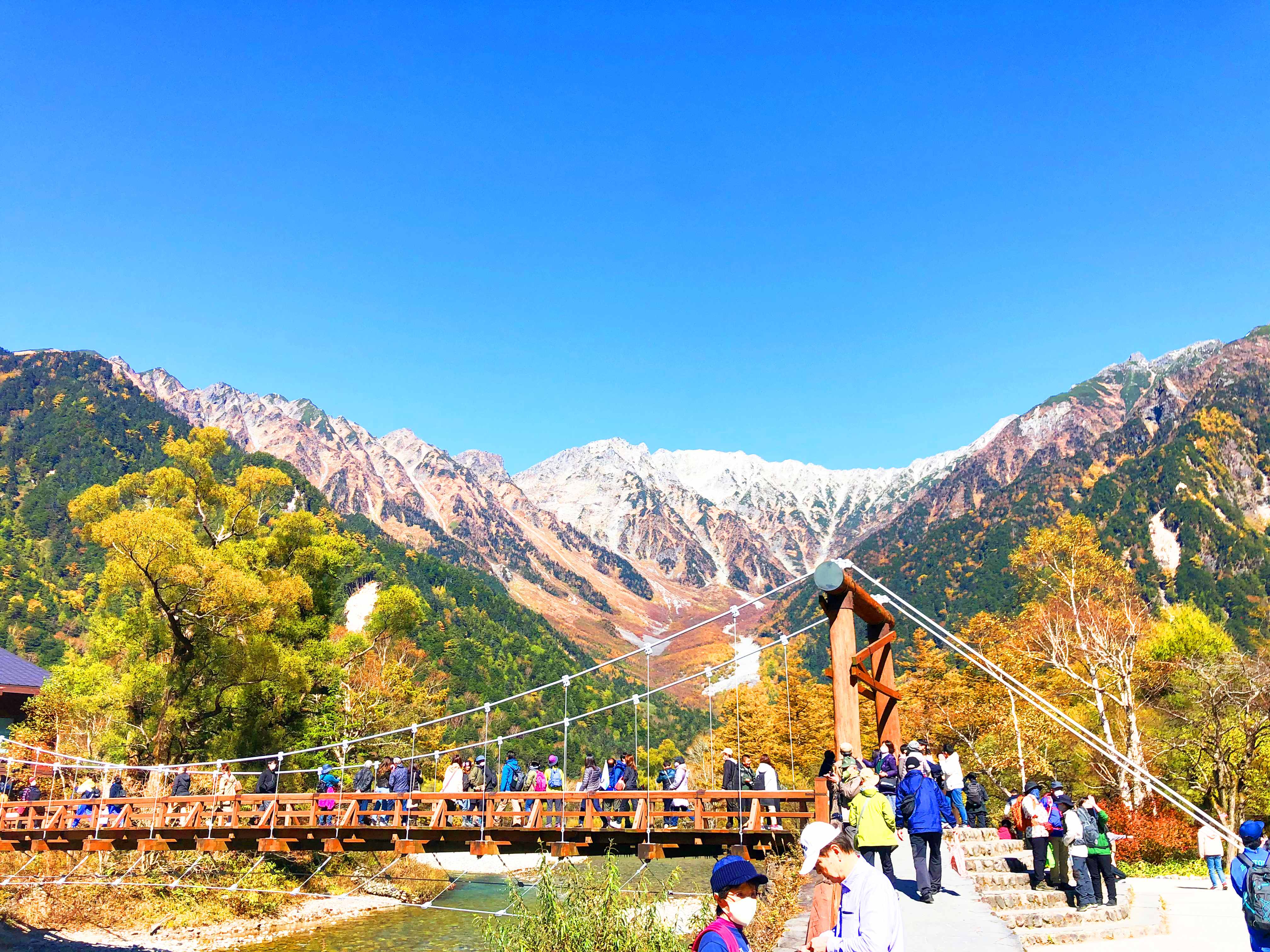
Kamikochi in brief: Kamikochi is a mountain valley in Matsumoto City, Nagano Prefecture, at about 1,500 m above sea level. The clear Azusa River, the wooden Kappabashi suspension bridge, and the jagged Hotaka mountain range behind it make it one of the most photographed places in the Japan Alps. Private cars are not allowed in, so everyone arrives by bus or taxi, which is part of what keeps the valley so quiet.

This guide is written by Misuzuso, a hot spring inn in Norikura Kogen at about 1,400 m. We are about 15 minutes by car from the Sawando shuttle bus stop, and many travelers use Norikura Kogen as a base for Kamikochi. The practical information below, such as bus fares, taxi fares, walking distances and rules, is based on the official Kamikochi website and the Alpico Kotsu bus company.

The name, the history, and Walter Weston

The name "Kamikochi" is said to derive from "Kamikouchi" (神河内), an old name for the area. The valley is the headwater of the Azusa River and has long been a place of mountain worship. Hotaka Shrine Okumiya, at Myojin Pond, is still regarded as the spiritual center of Kamikochi.

Kamikochi became widely known thanks to Walter Weston, an English missionary who climbed throughout the Japan Alps from the Meiji to the Taisho era and introduced them to the world. He is called the "father of modern Japanese mountaineering." A memorial relief of Weston stands near Kappabashi Bridge, and the Weston Festival is held every year in early June in his honor.

The landscape changed dramatically in 1915, when Mt. Yakedake erupted. The mudflow dammed the Azusa River and flooded the forest, creating Taisho Pond. The dead trees still standing in the water are a remnant of that eruption. Kamikochi was designated a special protection zone of Chubu-Sangaku National Park in 1934, and a Special Place of Scenic Beauty and Special Natural Monument in 1952.

A car-free valley

Kamikochi has been closed to private cars all year round since 1975. This was one of Japan's first nature-protection traffic restrictions, intended to protect the river and the quiet of the valley from exhaust fumes and noise. Private cars, rental cars, and motorcycles cannot go beyond the Kama Tunnel. Visitors park at Sawando (from the Matsumoto side) or Hirayu Akandana (from the Takayama side), and continue by shuttle bus or taxi.

AT A GLANCE

Kamikochi quick facts

LocationMatsumoto City, Nagano Prefecture, Japan (Chubu-Sangaku National Park)
ElevationAbout 1,500 m around Kappabashi Bridge
DesignationsSpecial Place of Scenic Beauty, Special Natural Monument, special protection zone of Chubu-Sangaku National Park
Open seasonAbout mid-April to mid-November (2026 buses: 17 April to 15 November). Closed in winter.
Getting inBy bus or taxi only. Private cars, rental cars and motorcycles are not allowed beyond the Kama Tunnel.
Main sightsKappabashi Bridge, Taisho Pond, Tashiro Pond and Marsh, Myojin Pond, Hotaka mountain range, Mt. Yakedake
Typical visit1–2 hours around Kappabashi; 4–5 hours including Taisho Pond or Myojin Pond
Best seasonsFresh greens (May–June), summer (July–August), autumn colors (early to mid October)
Nearest basesMatsumoto, Norikura Kogen (Misuzuso), Hirayu / Okuhida, and a few hotels inside Kamikochi

Source: Kamikochi official website (https://www.kamikochi.or.jp/). Multilingual site: https://www.kamikochi.org

GETTING THERE

How to get to Kamikochi

All routes end at Kamikochi Bus Terminal. Choose the route that matches where you start.

From Matsumoto (train + bus)Alpico Kamikochi Line from Matsumoto Station to Shin-Shimashima Station (about 30 minutes), then a bus to Kamikochi (about 1 hour).
From Matsumoto (direct bus)"National Park Liner" from Matsumoto Bus Terminal to Kamikochi (about 1 hour 30 minutes, 2 departures a day in 2026). Reservation-priority.
From Takayama / Hida sideBus from Takayama to Hirayu Bus Terminal (about 1 hour), then the Hirayu shuttle bus to Kamikochi (about 25 minutes).
By car from the Matsumoto sidePark at Sawando (about 2,000 spaces, about 800 yen per car per day), then take the shuttle bus or a taxi.
By car from the Takayama sidePark at Hirayu Akandana (about 600 yen per car per day), then take the shuttle bus or a taxi.
From Norikura KogenLocal bus to Sawando Bus Terminal and change to the Kamikochi shuttle. By car, Misuzuso is about 15 minutes from Sawando.

From Tokyo, Nagoya and Osaka

From Tokyo (Shinjuku): The Azusa limited express reaches Matsumoto in about 2 hours 40 minutes (departures about once or twice an hour between 7:00 and 21:00). A highway bus from Shinjuku Bus Terminal takes about 3 hours 15 minutes. From Matsumoto, continue by train and bus or by the National Park Liner. There is also a direct bus service from Shinjuku to Kamikochi by the Sawayaka Shinshu-go operated by Alpico.

From Nagoya: The Shinano limited express reaches Matsumoto in about 2 hours 8 minutes. Alternatively, take the Hida limited express to Takayama (about 2 hours 40 minutes), then the bus to Hirayu and the shuttle to Kamikochi.

From Osaka / Kyoto: Take the Shinkansen to Nagoya (about 1 hour from Shin-Osaka) and continue as above. A single daily Hida limited express runs from Osaka to Takayama (about 4 hours 25 minutes).

Reserving the bus from Matsumoto

The Matsumoto/Shin-Shimashima to Kamikochi buses and the National Park Liner are "reservation-priority": reserved passengers board first, and others can board if seats are available. Reservations open at 00:00 on the same day one month before travel. In peak seasons, such as summer weekends and the October foliage season, reserve in advance. Buses between Sawando and Kamikochi (the shuttle) do not require reservations.

Good to know. There is no direct bus from Kamikochi back to Matsumoto Bus Terminal. On the return trip, change from the bus to the train at Shin-Shimashima Station. Since 1 September 2026, buses from Kamikochi to Shin-Shimashima let you board only between Kamikochi and Sawando-ohashi, and a reservation-priority connecting bus runs from Kamikochi to Norikura Kogen and Shirahone Onsen via Sawando. Check the Alpico website for the latest timetables.

Shuttle bus fares from Sawando

The official Kamikochi website lists the Sawando to Kamikochi Bus Terminal shuttle at 1,600 yen one way or 3,000 yen round trip for adults, and 750 yen one way or 1,500 yen round trip for children. The bus also stops at Taisho Pond and in front of Kamikochi Imperial Hotel, so you can get off at Taisho Pond and walk toward Kappabashi. Fares are paid at the fare box or at the ticket counter. Only 1,000-yen notes can be changed on board, so have small bills ready.

Taxi fares

Fixed-fare taxis run from the Sawando parking areas. For a standard car (up to 6 passengers), the fare from the upper Sawando zone is about 4,200 yen to Taisho Pond, 5,100 yen to Kamikochi Imperial Hotel, and 5,400 yen to Kamikochi Bus Terminal (6,000 yen from the lower zone). For groups of 4 or more, the taxi fare per person can be comparable to or lower than the bus. The last taxi boards at 18:00. Sawando taxi dispatch: +81-263-93-3336; Kamikochi dispatch center: +81-263-95-2350. Fares from the Hirayu side are roughly 4,600 to 6,000 yen, plus the Abo Tunnel toll.

When you arrive at Kamikochi Bus Terminal

The terminal has public toilets, the Kamikochi Information Center (8:00 to 17:00; coin showers, baby carrier and wheelchair rental), the Kamikochi Tourist Center (restaurant, shops, luggage storage, bus ticket counter), a post office, and a clinic. Taxi stand is at platform 1, shuttle to Hirayu at platform 5, and shuttle to Sawando at platform 7. Kappabashi Bridge is a short walk from the terminal.

Sources: Kamikochi official website (access pages), Alpico Kotsu (timetables and fares). Information as of October 2026; schedules and fares can change.

HIGHLIGHTS

The best places in Kamikochi

🌉

Kappabashi Bridge

The symbol of Kamikochi and the best viewpoint. A wooden suspension bridge across the Azusa River with the Hotaka range behind it.

🏞️

Taisho Pond

A calm "water mirror" reflecting the mountains. Created when the 1915 eruption of Mt. Yakedake dammed the Azusa River.

💠

Myojin Pond

A sacred pond in the grounds of Hotaka Shrine Okumiya, reflecting Mt. Myojin on its still surface.

🌿

Tashiro Pond & Marsh

A marsh that appears suddenly from the forest. Flowers bloom from mid-June to early July.

🗻

Hotaka range & Yakedake

The rugged Hotaka peaks and the steaming volcano Yakedake are the stars of Kamikochi's scenery.

🌲

Dakesawa, Tokusawa, Yokoo

The quiet upper valley: Dakesawa Marsh, the former pasture at Tokusawa, and Yokoo, the gateway to Yari and Hotaka.

View of the Hotaka mountain range and the Azusa River from Kappabashi Bridge in Kamikochi

Kappabashi Bridge | The symbol of Kamikochi

The wooden suspension bridge over the Azusa River is the start of most visits and the best photo spot. The Hotaka range rises directly in front of you, and snow or autumn colors are reflected in the river below. Around the bridge you will find shops, restaurants, the Kamikochi Visitor Center, and the Information Center. Early morning, when the first sunlight touches the peaks, is especially popular.

Taisho Pond | A mirror made by a volcano

The mudflow from the 1915 eruption of Mt. Yakedake dammed the river and formed this pond. Dead trees still stand in the water. You can walk here from the bus terminal, but the standard route is to get off at the Taisho Pond bus stop and walk along the nature trail back to Kappabashi. At dawn the surface can be as still as a mirror.

Tashiro Pond and Tashiro Marsh | A quiet wetland

Halfway between Taisho Pond and Kappabashi, a small pond and marsh open up beyond the trees with a view of the Hotaka range. From mid-June to early July, flowers such as Japanese azalea and cotton grass bloom here. Tashiro Bridge and Hotaka Bridge connect both sides of the river, so you can combine the right-bank and left-bank trails.

Myojin and Myojin Pond | The sacred precinct of Hotaka Shrine

Walking north along the river from Kappabashi brings you to Myojin, the grounds of Hotaka Shrine Okumiya. Myojin Pond is made up of two ponds, Ichi-no-ike and Ni-no-ike, and reflects Mt. Myojin. An admission fee is required, but the untouched atmosphere is worth the visit.

The Hotaka range and Mt. Yakedake

Okuhotakadake (3,190 m, the third-highest peak in Japan) leads the Hotaka range, which can be seen from almost anywhere in Kamikochi. The sharp ridges and cirques have attracted climbers for over a century. Mt. Yakedake, an active volcano that still sends up steam, created Taisho Pond and shaped the valley.

Dakesawa, Tokusawa and Yokoo | The quiet upper valley

Dakesawa Marsh is about 30 minutes on foot from Kappabashi and is a small wetland with dappled light and clear groundwater. Beyond that lie Tokusawa, a wide meadow that used to be a pasture, and Yokoo, the base for climbing Yarigatake and the Hotaka peaks. Day visitors usually go as far as Myojin, but if you have time, continuing to Tokusawa lets you see a quieter side of Kamikochi.

SEASONS

Kamikochi through the seasons

🌸

Spring (late April to May) | Snow and fresh green

After the park opens around 17 April, the Hotaka ridge is still covered in snow while the trees below begin to bud. Few visitors and a quiet mood.

🌿

Early summer (June to early July) | Flowers and marshes

Flowers bloom in Tashiro Marsh and the greens are deepest around Myojin and Tokusawa. It is also the rainy season, so bring rain gear.

☀️

Summer (July to August) | Peak season

The busiest time of the year. Even though Kamikochi is cooler than the lowlands, the sun is strong and the weather changes quickly, so carry rain gear.

🍁

Autumn (early to mid October) | Golden foliage

Erman's birch and larch turn gold, contrasting with the clear river. Mornings and evenings can drop close to freezing, so bring warm clothing. Crowds ease toward the closing around 15 November.

Kamikochi is normally closed to regular visitors from about 16 November to 16 April. Winter access is limited to guided snowshoe tours and similar activities (see our winter Kamikochi article, in Japanese).
WALKING COURSES

Walking courses from 1 to 5 hours

Kamikochi has walking trails for every level of fitness and time. As a guide, you cover about 3 km per hour, not counting stops for photos or rest.

Nature trail (Azusa River course)About 4.0 km, about 80 minutes (loop around Kappabashi and Taisho Pond)
Kappabashi ↔ Taisho Pond (right bank)One way about 3.8 km, about 75 minutes
Kappabashi ↔ Taisho Pond (left bank)One way about 4.0 km, about 80 minutes
Kappabashi ↔ Myojin (right bank)One way about 3.0 km, about 60 minutes
Kappabashi ↔ Myojin (left bank)One way about 2.5 km, about 50 minutes
Myojin ↔ Tokusawa ↔ Yokoo (upper Kamikochi trail)One way about 6.5 km, about 130 minutes

Right bank vs. left bank

Trails run on both sides of the Azusa River. The right bank passes Tashiro Bridge and Hotaka Bridge and is flatter and easier. The left bank has more ups and downs and runs through quiet forest. Use one bank on the way out and the other on the way back to see different scenery on the same route.

1-hour courseEasy

Bus terminal → Kappabashi → right bank of the Azusa River → Weston relief → Tashiro Bridge → left bank → bus terminal

2-hour courseKappabashi ↔ Myojin, about 60 min / 3.0 km

Bus terminal → Kappabashi → left bank → Myojin Pond → right bank → Kappabashi → bus terminal

3-hour course

Bus terminal → Kappabashi → Myojin junction → Myojin Pond → Kappabashi → Weston relief → Tashiro Bridge and Hotaka Bridge → Nakanose Park → bus terminal

4-hour courseKappabashi ↔ Taisho Pond, about 75–80 min / 3.8–4.0 km

Bus terminal → Kappabashi → Visitor Center → Myojin Bridge → Myojin Pond → Kappabashi → Weston relief → Tashiro Bridge → nature trail → Taisho Pond round trip → bus terminal

5-hour courseAs far as Myojin and Tokusawa

Bus terminal → Kappabashi → Myojin → Tokusawa → Shinmura Bridge → Tokusawa → Myojin Bridge → Myojin Pond → Kappabashi → Weston relief → Tashiro Bridge → bus terminal

The upper Kamikochi trail (Myojin to Tokusawa to Yokoo) is about two hours one way, so bring rain gear and comfortable shoes. You may see birds such as the Japanese bush warbler and the Japanese robin. Beyond Tokusawa, Yokoo is the entrance to serious mountain trails to Yarigatake and Hotakadake, so for a day trip Tokusawa is a sensible turning point.

Tips for walking

The paths between Kappabashi and Tashiro Bridge/Hotaka Bridge are mostly boardwalk and gravel and are relatively easy. After rain, parts can be muddy, so waterproof shoes are reassuring. For strollers or more detailed path conditions, ask at the Kamikochi Visitor Center or the Information Center near Kappabashi.

Two sample plans

  • Half day (about 3 hours): Take the shuttle to Taisho Pond, walk the nature trail to Kappabashi (about 75 to 80 minutes), have lunch near the bridge, and take the bus back from the terminal.
  • Full day (about 5 hours): From the bus terminal, walk to Kappabashi, continue to Myojin Pond, return along the other bank, and finish at the bus terminal. Add Taisho Pond by bus if you still have time.
WEATHER & CLOTHING

Temperatures and what to wear

Kamikochi is a mountain resort at 1,500 m. In spring and autumn, temperatures swing widely between morning and daytime, and even in summer it can feel chilly when it is cloudy, rainy or windy. Layers that you can adjust, such as a quick-drying base layer, a long-sleeved shirt and a warm jacket, work best.

PeriodLate AprMayJunJulAugSepOctEarly Nov
Avg. high13.7°C16.2°C20.0°C23.0°C21.7°C20.0°C12.5°C8.9°C
Avg. low2.2°C4.7°C10.0°C13.7°C15.4°C12.1°C3.6°C-1.1°C

Calculated from data published by the Kamikochi Visitor Center (Ministry of the Environment), 2022 averages.

What to bring

  • Spring and autumn: long-sleeved shirt, fleece, mountain parka or down jacket, long pants, gloves and a hat.
  • Summer: T-shirt, long-sleeved shirt, windbreaker, shorts and a hat.
  • Shoes: For walks between Taisho Pond and Yokoo, comfortable sneakers are fine. In rain or mud, waterproof trekking shoes are better.
  • Rain gear: Mountain weather changes fast, so a rain jacket (or at least a folding umbrella) is essential.

In September, the high drops below 20°C and rowan and Erman's birch begin to color. Mornings and evenings can fall below 10°C, so bring a fleece and rain gear. Early to mid October is usually the peak of the autumn colors.

Checklist

  • Rain jacket and pants (separate pieces are best)
  • Warm layer (fleece or light down) for cold mornings and evenings
  • Comfortable walking shoes (waterproof if possible)
  • Hat for sun and rain
  • Drinks and snacks (there are shops, but fewer the farther you walk)
  • A trash bag, because there are no trash cans and you must carry your trash out
  • Some cash in small bills for buses and small shops

If you plan to climb beyond Kamikochi, such as Yarigatake or Hotakadake, helmets are recommended on some routes. Check the latest mountain information before you go.

PRACTICAL TIPS

Practical tips for visitors

  • Start early. The morning light is best, and the shuttle buses and the walking trails are less crowded before late morning. Check the last bus back before you set out; taxis stop boarding at 18:00.
  • Carry cash. Bus fares are paid at the fare box. Only 1,000-yen notes can be changed on board.
  • Facilities. Public toilets are at the bus terminal; check the park map for others along your route. Luggage can be stored at the Kamikochi Tourist Center. A post office and a clinic are near the bus terminal.
  • Food and drinks. There are restaurants, cafes and shops around Kappabashi and the bus terminal. Beyond Myojin, facilities become scarce, so bring drinks and snacks.
  • Weather and bus operation. Check the weather forecast and bus operation information in advance. Buses may be delayed or canceled by weather or road conditions.
  • Bear spray. Bear spray cannot be carried in the bus cabin. Seal it in a plastic bag inside your backpack and store the backpack in the luggage compartment.
  • Crowded periods. Summer weekends and holidays, the Obon period, and the October foliage season are especially crowded. On certain weekends, sightseeing coach buses are restricted from entering Kamikochi.
RULES & ETIQUETTE

Kamikochi's "5 Rules + 2"

To protect Kamikochi's nature, visitors are asked to follow five basic rules (plus two more):

  • No collecting: do not take plants or animals, including insects.
  • No feeding: do not feed wild animals.
  • No littering: take all your trash with you. There are no trash cans on the trails.
  • No bringing in: do not bring pets or non-native species.
  • No stepping off the path: stay on the walkways.
  • No bicycle riding on the trails.
  • No drones: unmanned aircraft are prohibited in the national park.

Smoking while walking is also discouraged. Please be considerate when taking photos by sharing popular viewpoints and not blocking the path. Japanese macaques and Asian black bears live in the area: keep your food sealed, do not approach wild animals, and never feed them.

Source: Kamikochi official website, "Rules and Manners" page.

WHERE TO STAY

Where to stay when visiting Kamikochi

There are hotels and mountain lodges inside Kamikochi itself, including Kamikochi Imperial Hotel, but the number of rooms is limited and prices tend to be high. During summer and the autumn foliage season, rooms fill up early. Many travelers instead stay in a nearby area and visit Kamikochi as a day trip: Matsumoto (city with trains and Matsumoto Castle), Hirayu and Okuhida (on the Takayama side), or Norikura Kogen.

Staying in Norikura Kogen

Misuzuso stands at about 1,400 m in Norikura Kogen, a highland resort in Chubu-Sangaku National Park. It is about 15 minutes by car from the Sawando shuttle bus stop for Kamikochi, and about 2 minutes by car from the bus stop for Mt. Norikura. The inn has a milky-white hot spring with source-flowing water, available 24 hours, as well as private baths and multi-course Japanese meals centered on wild mushroom hot pot. After a day of walking in Kamikochi, a soak in the hot spring is a good way to relax. Because we are in the highlands, summer is cool and comfortable.

Not sure how to plan your route? Please contact us. We are happy to give advice on getting to the Sawando bus stop and on connecting buses. See our access page for directions to Misuzuso, and our rooms, hot spring and plans pages for details.

FAQ

Kamikochi: frequently asked questions

What is Kamikochi and where is it?

Kamikochi is a mountain valley in Matsumoto City, Nagano Prefecture, at an elevation of about 1,500 m. It lies inside Chubu-Sangaku National Park and is designated a Special Place of Scenic Beauty and a Special Natural Monument. It is best known for Kappabashi Bridge, Taisho Pond, Myojin Pond, and views of the Hotaka mountain range.

How high is Kamikochi?

The center of Kamikochi, around Kappabashi Bridge, is at about 1,500 m above sea level. It is surrounded by peaks of about 3,000 m, including Okuhotakadake (3,190 m, the third-highest mountain in Japan) and the active volcano Yakedake.

How do I get to Kamikochi from Matsumoto?

Take the Alpico Kamikochi Line train from Matsumoto Station to Shin-Shimashima Station (about 30 minutes), then a bus to Kamikochi (about 1 hour). Alternatively, the "National Park Liner" runs directly from Matsumoto Bus Terminal to Kamikochi in about 1 hour 30 minutes, with two departures a day in the 2026 season. Both services give priority to reserved passengers, and reservations open at 00:00 one month before the travel date.

Can I drive to Kamikochi?

No. Private cars, rental cars, and motorcycles are not allowed beyond the Kama Tunnel all year round. From the Matsumoto side, park at the Sawando lots (about 800 yen per car per day) and take the shuttle bus or a taxi. From the Takayama side, use the Hirayu Akandana parking area.

How much is the shuttle bus from Sawando to Kamikochi?

According to the official Kamikochi website, the Sawando to Kamikochi Bus Terminal shuttle costs 1,600 yen one way or 3,000 yen round trip for adults, and 750 yen one way or 1,500 yen round trip for children. The bus also stops at Taisho Pond and Kamikochi Imperial Hotel. Fares may change, so check the Alpico website before you travel.

How do I get to Kamikochi from Norikura Kogen?

From Misuzuso in Norikura Kogen, the Sawando shuttle bus stop is about 15 minutes by car. Without a car, take the Alpico local bus from Norikura Kogen to Sawando Bus Terminal and change to the Kamikochi shuttle there. On the way back, a reservation-priority connecting bus from Kamikochi Bus Terminal (platform 6) to Norikura Kogen and Shirahone Onsen started running on 1 September 2026; check the Alpico website for the current timetable.

When is Kamikochi open?

The Kamikochi area is open to visitors from about mid-April to mid-November. In 2026, buses are scheduled to run from 17 April to 15 November. Outside this period the road is closed for the winter.

When is the best time to visit Kamikochi?

Fresh green leaves and remaining snow on the peaks appear from late April to June, July and August are the high season, and autumn colors (mostly golden-yellow larch and Erman's birch) are usually at their best from early to mid October. Weekends in summer and the October foliage season are the most crowded.

How much time do I need in Kamikochi?

Plan 1 to 2 hours if you only visit the area around Kappabashi Bridge. A walk that includes Myojin Pond or Taisho Pond takes about 4 to 5 hours. If you continue to Tokusawa or Yokoo, allow a half day or more.

Can I visit Kamikochi as a day trip from Tokyo?

It is possible but long. The Azusa limited express from Shinjuku to Matsumoto takes about 2 hours 40 minutes, followed by about 1.5 hours by train and bus or direct bus. Many travelers prefer to stay in Matsumoto or Norikura Kogen the night before so they can arrive early, before the crowds.

Where should I stay when visiting Kamikochi?

There are a limited number of hotels inside Kamikochi, and they fill up early in summer and during the autumn foliage season. Other options include Matsumoto, Hirayu and Okuhida on the Takayama side, and Norikura Kogen. Misuzuso is in Norikura Kogen at about 1,400 m, with a milky-white hot spring, and is about 15 minutes by car from the Sawando shuttle bus stop.

What should I wear in Kamikochi?

Kamikochi is cooler than the lowlands and temperatures change a lot between morning and evening, even in summer. Bring long sleeves, a warm layer such as a fleece, rain gear, and comfortable walking shoes. Waterproof trekking shoes are helpful on muddy paths.

Are there toilets, food, and luggage storage in Kamikochi?

Yes. The Kamikochi Bus Terminal has public toilets, an Information Center (8:00 to 17:00), and the Kamikochi Tourist Center with a restaurant, shops, and a luggage storage counter. There are also shops and restaurants around Kappabashi Bridge, but fewer facilities the farther you walk beyond Myojin.

Is it safe to walk in Kamikochi? What about bears and monkeys?

Japanese macaques and Asian black bears live in the area. Do not feed wildlife, keep food sealed, and keep your distance. Bear spray may not be carried inside the bus cabin; the Alpico bus company asks you to seal it in a plastic bag inside your backpack and store the backpack in the luggage compartment.

What are the rules for visiting Kamikochi?

Kamikochi follows "5 Rules + 2": do not collect plants or insects, do not feed wild animals, take all your trash home, do not bring pets or non-native species, and do not leave the paths. In addition, bicycles on the trails and drones are prohibited. Walking while smoking is also discouraged.

Last updated: 5 October 2026. Sources: Kamikochi official website (https://www.kamikochi.or.jp/), Alpico Kotsu (https://www.alpico.co.jp/).

Make Norikura Kogen your base for Kamikochi

15 minutes by car to the Sawando shuttle bus stop, and a milky-white hot spring waiting after a day of walking.

📞 Check Availability